Infrasound: Calculating Velocity Of Large D3 Avalanche
Overview
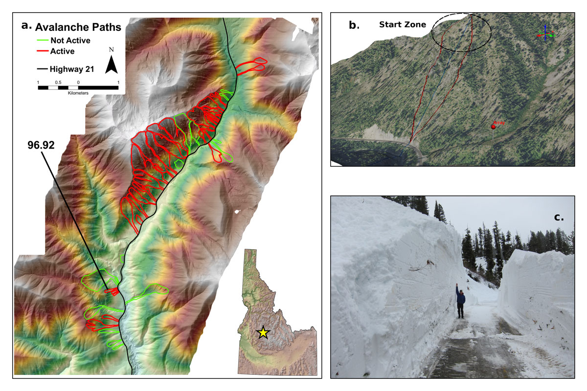
On 19 January 2012, a large D3 avalanche (approximately 103 tons) was recorded with an infrasound array ideally situated for observing the avalanche velocity. The avalanche crossed Highway 21 in Central Idaho during the largest avalanche cycle in the 15 years of recorded history and deposited approximately 26 feet (8 meters) of snow on the roadway. Possible source locations along the avalanche path were estimated at 0.5 s intervals and were used to calculate the avalanche velocity during the 64 s event. Approximately 10 s prior to the main avalanche signal, a small infrasound signal originated from the direction of the start zone. We infer this to be the initial snow pack failure, a precursory signal to the impending avalanche. The avalanche accelerated to a maximum velocity of 80 ± 17 mph (35.9 ± 7.6m s−1) within 30 s before impacting the highway. We present a new technique to obtain high spatial and temporal resolution velocity estimates not previously demonstrated with infrasound for avalanches and other mass wasting events.
The Avalanche Cycle
The avalanche cycle on 19 January 2012 proved to be one of the largest cycles that the Highway 21 corridor has ever experienced. Two separate avalanche cycles occurred during the seven day storm. The first avalanche cycle produced large dry avalanches while the second avalanche cycle produced medium wet avalanches. An automated weather station (10 mi north at Banner Summit) recorded 2.75 inches of water and approximately 22 inches of snow two and a half days prior to the first avalanche cycle.
After the storm cleared, 57 avalanches were reported with storm totals equaling 53 inches of snow and 5 inches of water. Thirty seven avalanches left debris on the highway with debris pile depths ranging from 5 to 26 feet deep. Figure 1a provides an overview of the highway corridor and the avalanche paths that were active during the avalanche cycle.
The Avalanche
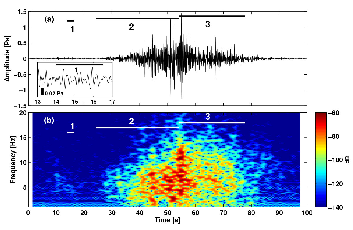
The signal amplitude shows the classic infrasound signal characteristics of an avalanche. The avalanche gradually increases (t = 30 s) amplitude as it gains momentum and size. As it approaches the highway it begins to decrease amplitude (t = 60 s) and eventually stops. A maximum pressure of just under 1.5 Pa (t = 55 s) was recorded at a distance of approximately 1000 feet.
A small precursory signal was recorded, 14 s prior to the signal within the avalanche start zone. We hypothesize that the signal was from the snowpack fracture propagation which displaced the snowpack and caused the pressure wave in the air (i.e., a “whumpf”). We believe that this is the first published example of a potential snowpack failure event captured remotely on an infrasound array.
The Avalanche Velocity
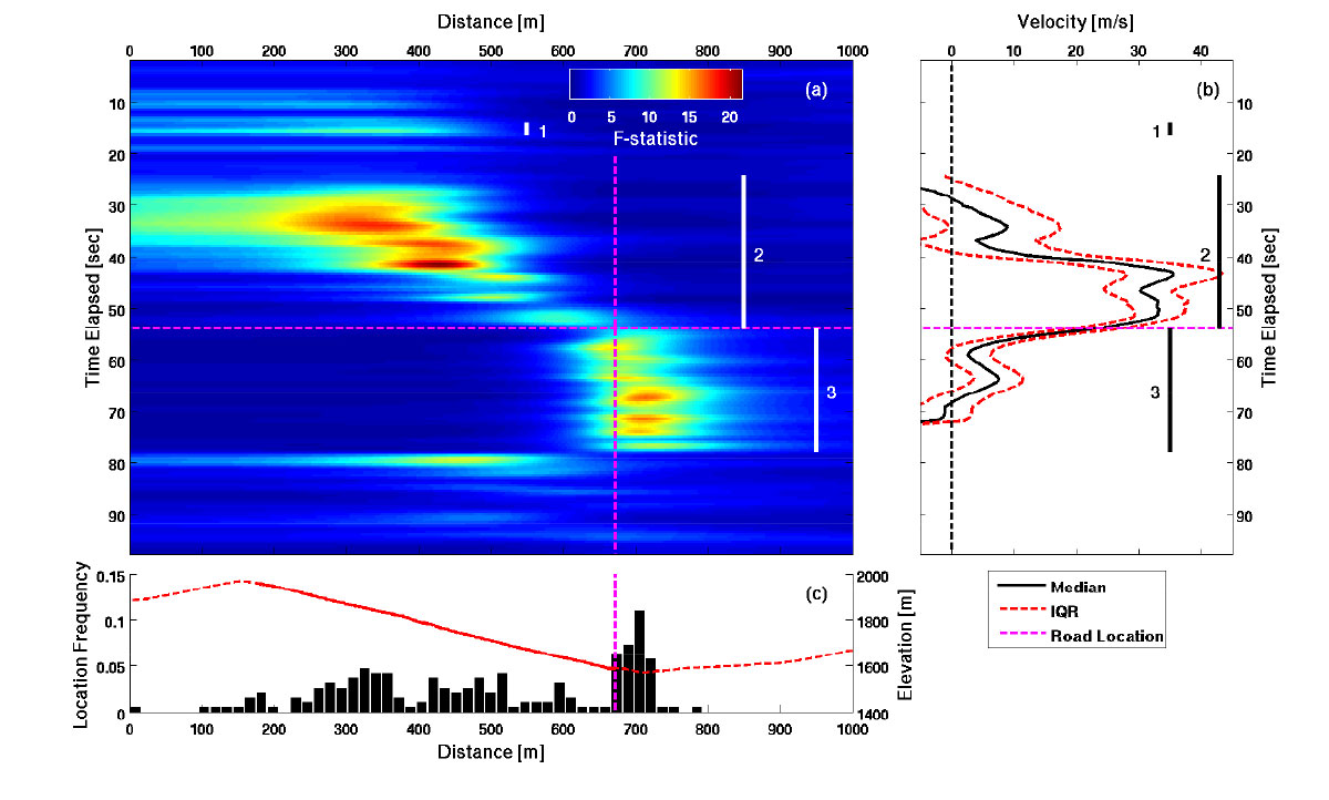
The average velocity of the avalanche was 33 mph from the first major signal at 24.2 seconds to the impact with the highway at 54.0 seconds. The average velocity was of reasonable magnitude, however, the velocity of the avalanche was highly path dependent. The avalanche most likely did not have enough time to reach a steady terminal velocity. It is also possible that the avalanche was still accelerating when it impacted the highway.
The measured avalanche velocity can be described by the velocity of a mass-gaining momentum as it moves down slope. Initially, the velocity was small as the initial snow mass began to move. As the avalanche gained momentum, a suspension layer likely formed and produced a high-amplitude infrasound signal with high signal correlation. The avalanche accelerated quickly to a maximum velocity of 80 ± 17 mph within approximately 1000 feet of the highway as more snow was entrained right before it impacted the highway.
Summary
The detection of the 19 January 2012 avalanche is the first time velocity time series of an avalanche that was tracked from beginning to end using an infrasound array. The average velocity of the avalanche calculated (33 mph) was significantly less than the estimated maximum velocity of 80 ± 17 mph and was in the lower range of previous observations. The lower velocity is likely due to the relatively short avalanche path.
The large avalanche had three distinct phases. The avalanche started with the failure of the weak layer 10 s prior to the first detectable signal of the avalanche. We believe this to be the first time a possible weak layer failure has been captured using infrasound. Having the array 1800 feet from the start zone allowed for the detection of the small amplitude signal. Once the avalanche gained momentum, it quickly accelerated downslope to a maximum velocity of 80 ± 17 mph before impacting the highway. After the avalanche reaches the highway and begins to lose momentum, it takes 23.8 s for the remaining debris to fill the creek below.